
 The quick and Easy-to-use Monitoring Solution
Upload, store, calculate and view your monitoring data for any location
• Store and protect monitoring data in the cloud with just a couple of steps
• Upload, calculate and visualize monitoring data quickly and easily
• Access data from anywhere in the world using a smartphone, tablet or laptop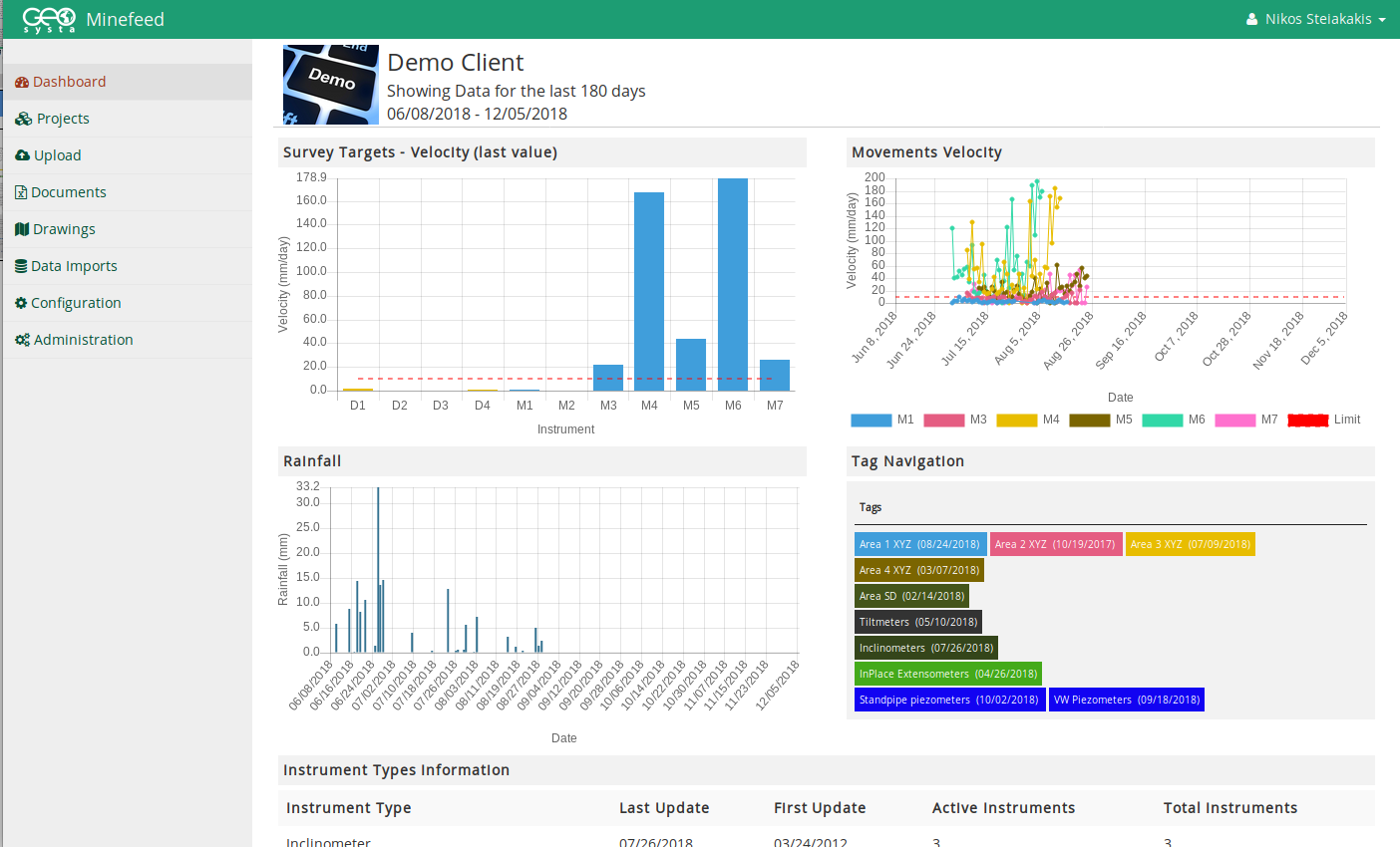
• Upload monitoring data manually or automatically
• Easily evaluate monitoring data graphically and produce reports via web browser
• Assess alarms when measurements exceed given limits
• Immediately access and evaluate monitoring data after it has been uploaded from field device
Locate monitored locations and devices
• Google maps
• Aerial photographs
• Geolocated imagery
Evaluate easily
 Minefeed provides functionality for in-depth evaluation of monitoring data and provides automatic calculation of:
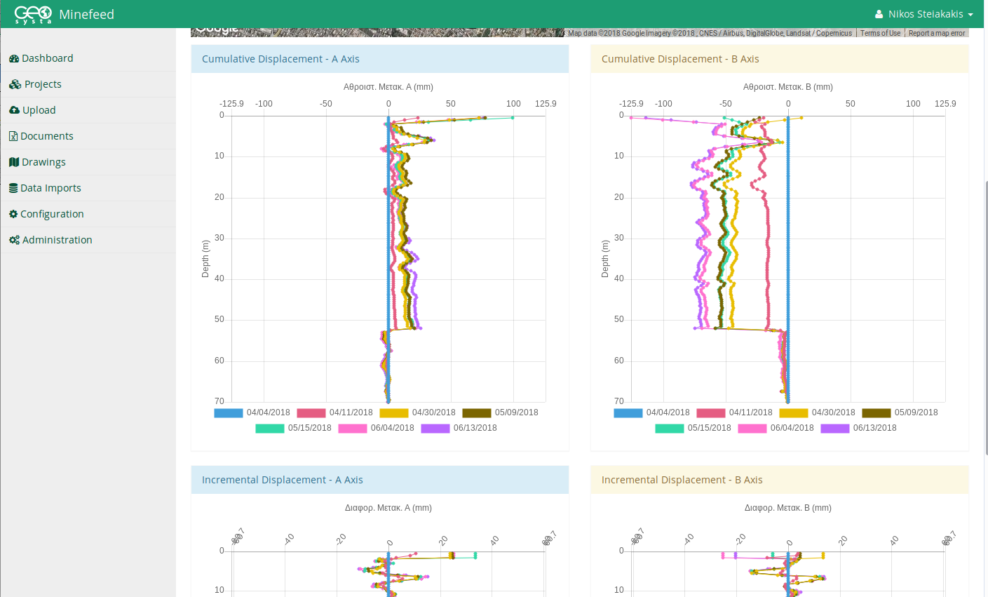
• Survey displacements, rates, and vectors
• Inclinometer readings
• Pressures and deformations from vibrating wire transducers (piezometers, strain gauges, etc.)
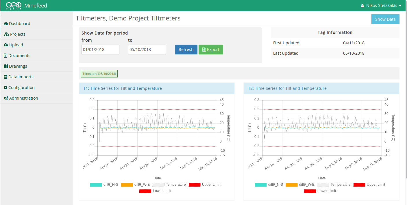
• Tilts and angles from Tiltmeters
• Displacements from settlement gauges
• Rainfall from precipitation gauges
• Pressures and elevations from standpipe piezometers
and more…
Generate reports and monitor from anywhere
•  Organize monitoring devices and monitoring locations in different tags and view the automatically calculated monitoring results quickly and easily
• View stored monitoring data for any time period
• Export data in excel format
• Create monitoring reports or view at a glance
• Assign any number of users to upload, access and evaluate the monitoring data
Integration
Any type of monitoring device connected via a datalogger and network connectivity can be set up to automatically upload the data into Minefeed without the need of manual operations. All raw monitoring data such as survey displacements, pore pressures, settlement gauge measurements, tiltmeter, and inclinometer measurements, etc. are automatically used in calculations to generate any time series graph.
Export any type of stored measurements in excel files for any selected time period and generate quick reports for any time period, any location, or any monitoring device with just one click and send them to a client or manager.
Integrate input from different software applications and devices. Manage all of your data in one place. Combine different data streams such as displacements with precipitation, tilt angles with temperature, and more.
Flexibility
 Any type of monitoring file can be easily uploaded in the system with a couple of clicks. Text or excel type of monitoring data collection files can be uploaded. Minefeed currently supports import types from some of the major sensor and equipment vendors. Implement importing and calculations for almost any kind of monitoring data files.
Unlimited User Accounts per Project
Authorized users can simultaneously view the monitoring data from any device, any time and any location as long as there is Internet access.
Cloud-Based Access
Minefeed is a modern cloud-based web application with the latest features in information technology users’ monitoring needs. Access all monitoring data in the Minefeed portal through a web browser. No software installation required.
Protection from Data Loss
Safeguard data from power outages, hardware failures, etc. Utilizing resources from major cloud services vendors — Minefeed is set to be constantly available. Data visualization such as charts and maps are created using the latest innovations in browser based components, so adjustments can be made and data can be viewed quickly without long downloads.
Minefeed is developed by Geosysta Ltd